Introduction
India is one of South Asia’s most strategically important countries because it is in the middle of the continent. India shares borders with many countries, which affects its relationships with other countries in the region. India has a large land area, a rich cultural past, and a changing government system.
Understanding India and its neighbouring countries is crucial for students’ academic success. But learning about geography, foreign ties, and being a good global citizen is also necessary. Students can better understand how India’s borders affect trade, security, and relations in the area if they know about its history, geography, and borders.
List of India’s Neighbouring Countries
India shares its land and maritime boundaries with several countries. This makes it one of the few nations with such a diverse set of neighbours.
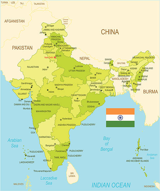
A Labelled Political Map Of India That Shows All Bordering Countries
Land Borders
India shares land borders with seven countries:
- Pakistan
- China
- Nepal
- Bhutan
- Bangladesh
- Myanmar
- Afghanistan (via the Pakistan-occupied Kashmir region)
Maritime Borders
India also has maritime borders with:
- Sri Lanka
- Maldives
This list forms the foundational understanding of India and its neighbouring countries, helping students grasp the broader regional map.
Geographical Features of the Borders
The geography of India varies significantly across its borders, which are shaped by mountains, rivers, forests, and seas.
- Himalayan Region: The northern borders of India, shared with China, Nepal, and Bhutan, are dominated by the Himalayan mountain ranges. These natural barriers provide both protection and isolation. This region includes snow-covered peaks, deep valleys, and high-altitude passes.
- Plains and Rivers: To the east, India shares its border with Bangladesh, which is characterised by fertile plains and major rivers like the Ganges, Brahmaputra, and Meghna. On the west, the border with Pakistan includes the Thar Desert and the fertile Punjab plains, intersected by the Indus River.
- Coastal Borders: India’s southern borders, shared with Sri Lanka and the Maldives, are maritime in nature. These borders stretch across the Indian Ocean, with the Palk Strait and the Gulf of Mannar separating India from Sri Lanka.
Border Lengths and Key Bordering States
India has a land border of 15,106.7 km and a coastline of 7,516.6 km, including maritime boundaries (Source: Ministry of Home Affairs, Government of India).
Here are the approximate border lengths India shares with its neighbours:
- Bangladesh: 4,096.7 km (longest)
- China: 3,488 km
- Pakistan: 3,323 km
- Nepal: 1,751 km
- Myanmar: 1,643 km
- Bhutan: 699 km
- Afghanistan: 106 km (via PoK, not under Indian control)
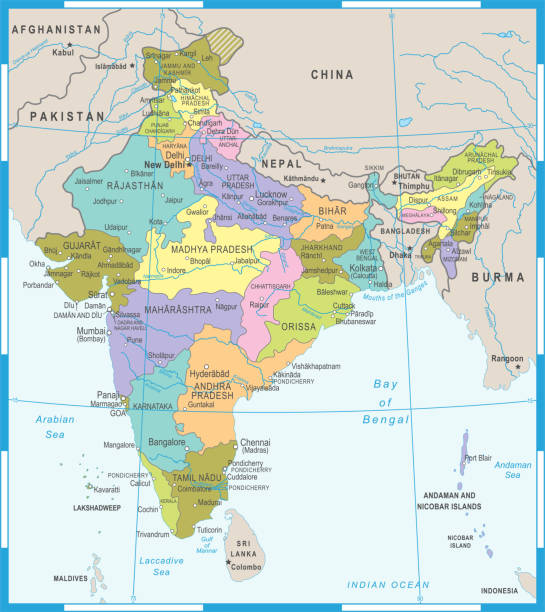
A State-Wise Map Of India With Highlighted Borders
Key Indian States Sharing Borders:
Pakistan
- Punjab
- Rajasthan
- Jammu & Kashmir (now split into J&K and Ladakh)
- Ladakh
China
- Ladakh
- Himachal Pradesh
- Uttarakhand
- Sikkim
- Arunachal Pradesh
Bangladesh
- West Bengal
- Assam
- Meghalaya
- Tripura
- Mizoram
Myanmar
- Arunachal Pradesh
- Nagaland
- Manipur
- Mizoram
Nepal
- Uttarakhand
- Uttar Pradesh
- Bihar
- West Bengal
- Sikkim
Bhutan
- Sikkim
- West Bengal
- Assam
- Arunachal Pradesh
Afghanistan
- Border exists through Pakistan-occupied Kashmir (disputed territory)
This data clarifies India’s border length and connects it to the political geography of the Indian states.
Historical Context of Borders
Understanding how these borders came into existence is crucial to studying India and its neighbouring countries.
- Partition of India (1947): As a result of the Partition, Pakistan was born. In the northeast and northwest, it drew new borders. Although this aspect is still up for debate, the split indirectly established a border with Afghanistan.
- Treaty of Sugauli (1815): British East India Company and Nepalese monarchy officials signed this deal. There has been relative calm between India and Nepal ever since it mapped out much of their present-day boundary.
- McMahon Line (1914): During the Simla Convention, this was the proposed line between British India and Tibet. Despite China’s complaints about its legitimacy, it serves as the de facto boundary between the two countries, especially in Arunachal Pradesh.
- Recent Developments: Tensions between India and China are seen in border clashes (such as the incident in Galwan Valley in 2020). The Land Boundary Agreement (2015) between Bangladesh and India settled boundary issues and exchanged enclaves.
Importance of Understanding Borders
It’s not enough to just memorise maps to understand limits. It helps you learn to think critically about society, politics, and geography. This is why it’s essential to know about India’s borders:
- Educational Significance: A key component of school geography is learning about India and its neighbouring countries. It helps you learn how to read maps, understand space, and be more aware in general.
- Geopolitical Awareness: Regarding trade, defence strategy, and foreign policy, borders matter. Students can more effectively follow current events by comprehending the borders of India with Pakistan, China, Nepal, and other nations.
- Cultural Insights: Borders also affect how people from different cultures interact with each other. India has much in common with its neighbours regarding language, food, and traditions, especially with Nepal, Bangladesh, and Sri Lanka.
Interactive Activities for Students
Students can try hands-on activities that enhance memory and understanding to make learning about India and its neighbouring countries more engaging. Here are a few simple and fun exercises:
Map Labeling
Give students a blank political map of India and ask them to:
- Label all neighbouring countries of India
- Colour-code land and maritime borders
- Mark the capitals of each neighbouring country
Quiz
Ask questions like:
- What is the capital of Bhutan?
- Which state shares borders with Myanmar and Bangladesh?
- What separates India and Sri Lanka?
Discussion
Organise a classroom session where students can discuss:
- “Why is peaceful border-sharing important for economic growth?”
- “Should borders be open like the India-Nepal model?”
Conclusion
India’s borders are not just political lines on a map but gateways to history, culture, and diplomacy. Each border tells a unique story, from the snow-covered mountains of the north to the tropical seas of the south. A thorough understanding of India and its neighbouring countries equips students with knowledge that is essential for academic success and informed citizenship.
Encourage yourself to explore beyond textbooks. Study the maps, watch documentaries, and read about India’s neighbours to appreciate the beauty and complexity of South Asia.
FAQ
Which countries share a border with India?
India shares land borders with Pakistan, China, Nepal, Bhutan, Bangladesh, Myanmar, and Afghanistan. Maritime borders are with Sri Lanka and the Maldives.
What is the length of India’s land border?
India’s total land border is approximately 15,106.7 km. (Source: Ministry of Home Affairs)
How many states share borders with India’s neighbours?
18 Indian states and union territories share borders with neighbouring countries.
What are the major geographical features of India’s borders?
India’s borders feature the Himalayas in the north, river plains in the east and west, and coastal waters in the south.
Why is understanding India’s borders important?
It enhances geographic literacy, builds regional awareness, and fosters a deeper understanding of historical, political, and cultural dynamics.